Tables
Table 1: Comparison of 1980 - 1990 Population Characteristics: Bay Creek and City of Madison
Charts
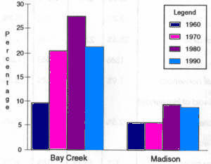
Chart 1: Persons 65 years or older
Chart 2: Single-Family Housing Turnover
Chart 3: Average Sales Price by Area
Maps
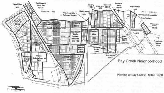
Map 1: Platting of Bay Creek (1889 - 1960)
Map 2: Existing Land Use
Map 3: Neighborhood Subareas
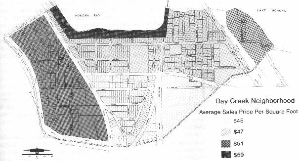
Map 4: Average Sales Price per square foot
Map 5: Structural Building Conditions
Map 6: Collectors and Arterial Streets
Map 7: Bike Routes
Map 8: Bus Routes
Map 9: Existing Zoning
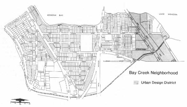
Map 10: Urban Design District
Map 11: Land Use Plan
Map 12: Outside Forces Posing Potential Opportunities and Threats
Appendices
Appendix 1: Structural Condition Evaluation Criteria
Appendix 2: Common Council Resolution
| Prepared by: | The Planning Unit of the Department of Planning and Development
George E. Austin, Director, Department of Planning and Development Bradley J. Murphy, AICP, Planning Unit Director | Neighborhood Steering Committee: | Margo Dameier, Chairperson Paul Gibler, Vice-Chairperson Gerald Anderson Merle Bailey Omie Baldwin Martin Garment Carol Kean Terri Michel Pat Mitchell Laurel Munger Kathy Raushar Aldo Trameri William Wade Brian Yandell |
|---|---|---|---|
| Project Staff: | Jule A. Stroick, Project Manager Enid Drevon, Planning Aide Katherine Rankin, Planner III Archie Nicolette, Planner II Debora Morgan, Program Assistant III | ||
| Consultants: | University Planners Collaborative Department of Urban and Regional Planning Jerry Kaufman, Professor Marta Escuin Alicia Mazur Robert Nightingale Rick Roll |
Special thanks to Alderperson Napolean Smith, former City of Madison
Alderperson Sally Miley and Dane County Supervisor Sue Herbst for their support.
This project was supported by City of Madison Community Development Block Grant funds from the U.S. Department of Housing and Urban Development (HUD). | |
The Bay Creek neighborhood, coterminous with census tract 13.98, is bounded on the north by Monona Bay and in the other three directions by gently meandering Wingra Creek. Bay Creek, like other Madison neighborhoods, has a variety of distinguishing features.
Even with its many attributes, Bay Creek is still one of the least known of Madison's downtown neighborhoods. One reason
for Bay Creek's concealment is that, until recently, it didn t have an active organization focusing on neighborhood-wide issues
and fostering the neighborhood's image. In fact, the neighborhood's name, Bay Creek, was only recently conferred on the
neighborhood by the planning study Steering Committee.
Neighborhood Planning Process
Overall, there are numerous resources in Bay Creek: affordable and structurally sound housing, a good location, a diverse population, and access to ample water and recreation resources. The neighborhood has experienced a decade of transition, however. Increasingly, younger families and households are moving into Bay Creek. Some parts of the neighborhood, particularly along Monona Bay and south of West Olin Avenue have experienced a high rate of housing turnover. With the opening of the six-lane South Beltline, John Nolen Drive is becoming the principal gateway into the city.
Bay Creek's future will be influenced by several factors. Government agencies and private sector intermediaries will influence housing, business, and public facility service investment decisions. Bay Creek residents, especially the neighborhood association, will also have extensive input into Bay Creek's future directions. This planning report elaborates on the neighborhood's trends and environment, strengths and weaknesses, future opportunities and threats, and actions it can take to best realize its potential. Bay Creek has the opportunity to become one of the most livable older neighborhoods in Madison.
In Spring 1989, the Community Development Block Grant Commission (CDBG) selected Bay Creek to receive planning assistance and funding. The City establishes a three year schedule for concentration neighborhoods. The first year the City provides neighborhoods with a year of planning services. This is followed by submitting a package of proposals addressing major local opportunities for improvement during the subsequent two year period of CDBG funding.
To begin the Bay Creek planning process the CDBG office, working through the Madison Department of Planning and Development neighborhood planning unit, enlisted the help of the University of Wisconsin's Department of Urban and Regional Planning. Four second year graduate-level planning students Marta Escuin, Alicia Mazur, Robert Nightingale, and Rick Roll, worked under the direction of Professor Jerry Kaufman. This comprised the University Planners Collaborative (UPC) which provided planning services to the neighborhood steering committee.
The Neighborhood Steering Committee (NSC), a group of approximately 15 residents, met with UPC five times between September
1989 and January 1990. During these meetings NSC provided input and direction, set priorities, and responded to UPC's ideas and
recommendations. A sixth meeting was held on February 21, 1990. During this meeting a draft of the plan was presented to about
50 neighborhood residents attending the public meeting.
Neighborhood Information Gathering
UPC undertook scanning studies to assess the neighborhood's strengths and weaknesses as well as future opportunities and threats facing the neighborhood. In this initial phase the UPC:
Based on the findings from the scanning studies, UPC, with the advice and concurrence of the Neighborhood Steering Committee, selected six strategic issues to work on more intensively. Framed as objectives, the strategic issues are: to improve the image of the neighborhood, to attract and retain businesses, to better serve the needs of the elderly, to enhance the neighborhood's environmental and recreational resources, to improve traffic conditions, and to improve and/or maintain housing conditions.
UPC proposed action recommendations for each strategic issue. The Neighborhood Steering Committee reviewed and ranked them
according to priority. Each of the recommendations is dimensioned later in the plan. The recommendation is explained, the key
actors identified, the time frame developed, and the estimated costs and funding sources explored.
Neighborhood History
European-born settlers first arrived to Madison in 1837. Within twenty years, Madison was incorporated into a city, with an imposing capitol building, flour mills and sawmills, four-story office blocks, frame worker's cottages, sandstone mansions and 12,000 residents.
Just across the lake, however, the present Bay Creek neighborhood remained rural and remote. Peat marshes covered much of the area, making travel impossible in the spring and difficult after heavy rains. A large hill of sand rose south of where Haywood Drive is today. The site of several Indian burial mounds, and an unofficial early pioneer cemetery, it became known as Deadman's Ridge. Madison's first railroad line, built in 1854, ran through the eastern part of the Bay Creek area on the tracks of the old Milwaukee Road. The Chicago and Northwestern soon added another line to the west, completed in 1864.
In 1861, when a surveyor began to prepare a plat map of Dane County, there were only six buildings in the entire area. Four small houses were clustered around the corner of Beld (then part of the Oregon Road) and Wingra Creek. A large sandstone mansion called Belle Colline sat on a tall hill where the Romnes Apartments are presently located. A vacant, six-year-old sanitarium, known as the Water Cure, overlooked Lake Monona from the Olin-Turville Park area.
Following the Civil War, the defunct sanitarium was converted at a great expense into a summer resort hotel and the grounds laid out as a pleasure park. Madisonians and tourists from St. Louis and the south, ferried across the lake by steamboat, enjoyed the scenic vacation spot until the hotel was destroyed by fire in 1877.
Construction elsewhere in the Bay Creek neighborhood was sporadic, and accommodated households with wage earners who walked to work each day on the railroad bridges across Monona Bay.
In the late 1880s, Madison's population rapidly increased. This was partly due to the growth of the university and partly
due to the development of several large manufacturing interests, such as Gisholt. The swell spilled over into Bay Creek. In 1889,
T.C. Richmond, the owner of Belle Colline , platted some of the land west of his house as South Madison. In the same year
Grand View was platted, and George Lawrence platted a small section of lakefront property as the Monona Subdivision. Several
other parcels of land were also divided, including Pleasant View (1890), Oaklawn Addition (1890), Maple Court (1896), Woodlawn
(1898), and Lakeside (1901). (See Map 1).
By 1902, the 400 residents of these plats thought of themselves as members of a separate community, South Madison. They truly were a diverse group, with people of German, Scandinavian, Russian, Irish, Bohemian, English, American and Dutch ancestry. Laborers lived side by side with building contractors and wealthy lawyers. These residents built a church at 610 West Olin Avenue (now Second Baptist) that was shared by many denominations. A small, frame schoolhouse was built on Potter Street (just to the southwest of where Franklin School is now). The Chicago and Northwestern had just completed a wooden railroad depot just north of Lakeside Street and a streetcar line would soon be built along Lakeside Street connecting South Madison to the downtown. New store buildings sprang up at 335 and 402 West Lakeside Street and at 423 West Olin Avenue. In 1900, the Badger Shoe Factory, a major industry that had moved from Milwaukee to South Madison, opened at 1335 Gilson Street. The factory moved to larger quarters in 1910, and the old plant on Gilson was demolished a couple of years ago.
Even with all this development, the scenic beauty of the area had not been lost. The old sanatorium site was purchased in 1882 to serve as the Monona Lake Assembly. Begun as a summer camp for Sunday School teachers, the assembly became very popular. Soon, 15,000 people congregated in tents for several weeks each summer to swim, play, listen to live musical performances and hear inspirational, intellectual and political lectures. The 1884 normal lecture hall in Olin-Turville Park is now the only remnant of this once nationally-known resort. It was purchased for a city park in 1912. A new sanitarium was erected nearby in 1902 at 202 East Lakeside Street (formerly Victory Life Center 4-Square Gospel Church with a modern church building). In 1890, the Dane County Agricultural Society purchased the old Lakeside Farm south of Wingra Creek to serve as the new Dane County Fairgrounds.
As more and more people moved to Bay Creek, some of the marshy land became filled. Dredging operations in Monona Bay yielded sand to fill the marsh along its shore. The Madison Park and Pleasure Drive Association built a concrete walk along the lakeshore (now West and South Shore Drive). The group hoped in vain that the walk would someday extend completely around the lake.
In 1923 South Madison was annexed by the City of Madison, sparking more improvements in this thriving community which now numbered around 1,400. A new schoolhouse was built (the main section of Franklin School); streets were paved; sewer and water were installed. Many new houses were built and new shops were added to the small commercial area on Lakeside Street near the railroad depot. The new shops included another grocery store, a tailor shop, a shoe store, a pool hall, a barbershop and a bank. The Seventh Day Adventists built a church and school at 1124 Colby Street in 1924.
During the 1930s there was less home building but more public improvements. The old mansion on the hill was razed and the
hill itself leveled by the City to provide fill for the arboretum, Wingra Creek Parkway, Franklin Field and the new extension of
West Olin Avenue to the fairgrounds. Deadman's Ridge was also leveled to help fill in the marsh west of Fish Hatchery Road.
Following World War II, houses and apartment buildings quickly filled this pleasant residential neighborhood overlooking Wingra
Creek.
Neighborhood Scanning Studies
The Bay Creek strategic planning process began by determining current physical, social and economic conditions, and how they are changing. The scanning studies served as building blocks for learning about the neighborhood's current strengths and weaknesses as well as opportunities and threats that may affect it in the future.
According to the 1980 and 1990 Census information, Bay Creek's population differed significantly from the city's overall population in several respects (See Table 1):
| Bay Creek 1980 | Bay Creek 1990 | City 1980 | City 1990 | |
|---|---|---|---|---|
| Population | 2780 | 2707 | 170,616 | 190,766 |
| % Less than 14 years | 8.4% | 12.0% | 15.0% | 15.3% |
| % 65 years or older | 28.4% | 22.8% | 17.4% | 9.3% |
| Households | 1366 | 1335 | 66,451 | 77,361 |
| % Persons per household | 1.9% | 1.9% | 2.4% | 2.3% |
| % Female Head of Household with Children | 2.5% | 3.9% | 5.1% | 5.4% |
| % Female Head of Household 65 years or older | 32.0% | 15.1% | 18.0% | 6.3% |
| % Family | 56.9% | 56.2% | 66.9% | 63.5% |
| % Minority | 4.9% | 7.6% | 5.7% | 9.3% |
| Median Family Income | $19,583 | $36,581 | $22,856 | $40,799 |
| Median Household Income | $12,646 | $24,024 | $16,510 | $29,420 |
Source: 1990 Census of Population
Bay Creek's population composition has gradually changed over the last decade. An increasing amount of young families and young professionals are moving into the neighborhood. The following data support these conclusions:
Bay Creek's land uses range from single family homes to industry. Its 260 acres (approximately four tenths of a square
mile) is almost fully developed with only a few vacant parcels. In surveying the neighborhood's land use pattern, the UPC found
that the existing land use pattern is relatively unchanged since the last survey was conducted 15 years ago. Bay Creek's existing
land use pattern is shown on Map 2 and described below.
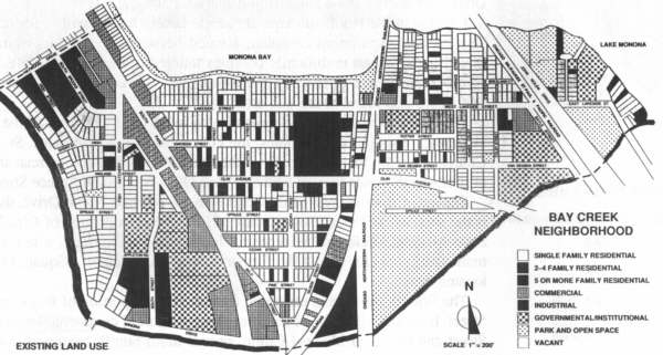
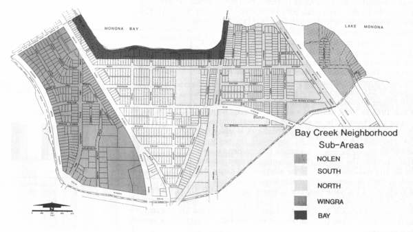
For planning purposes, Bay Creek has been divided into five sub-areas. As depicted on Map 3, these sub-areas are: North
(the area north of West Olin Avenue and east of South Park Street); South (the area south of West Olin Avenue between Park Street
and Franklin Field); Nolen (the area East of John Nolen Drive); Wingra (the area west of Park Street, south of Haywood and east
of Wingra Creek), and Bay (the block bordering South Shore Drive). Each has some distinguishing characteristics.
Located in the North sub-area are single family homes with a scattering of two-flats. The Romnes Apartment complex, located between West Olin Avenue and Lakeside Street, is the largest multifamily complex tailored to serve older adults. Lakeside Street commercial area, a portion of the South Park Street commercial'strip, and Franklin School are also found in this sub-area.
The South sub-area has the most diverse mixture of land uses of the five. Included in this area are single family homes, the Gilson Street industrial area, St. Mark's Lutheran Church, Franklin Field, a portion of the South Park Street commercial strip, and a cluster of multi-family units located between West Olin Avenue and Spruce Street.
Separated from the rest of the neighborhood by John Nolen Drive, the Nolen sub-area is the smallest and most isolated part of Bay Creek. A portion of Olin-Turville Park, the State Medical Society of Wisconsin, the Causeway Overlook, a few single family and multi-family dwellings and the former Victory Life Center 4-Square Gospel Church are located there.
The Wingra sub-area is separated from the largest portion of Bay Creek by South Park Street. It includes Bay Creek's largest concentration of commercial uses along South Park Street and the Dean Medical Clinic, several multi-family apartment complexes, and the Park Street Branch Post Office. Along Wingra Drive there are single-family homes.
The Bay sub-area is a small section that extends along South Shore Drive and is entirely made up of single-family homes. Many of Bay Creek's most expensive homes, Bernie's Beach and a linear park that extends along Monona Bay are also located there.
Approximately half of Bay Creek's land area (136 acres) is devoted to residential uses. The primary residential use is single-family homes on small lots ranging from approximately 4,400 square feet to 12,000 square feet. These single-family homes comprise approximately 74%, or 100 acres, of all residential land in the neighborhood and represent a variety of revival, bungalow, and modern vernacular style homes.
Bay Creek has 487 multi-family units. The multi-family units total 34.5 acres (26% of all the residential land). Of the 487 units, 144 are in duplexes, 89 are in buildings with three and four units and 254 are in buildings with five or more units. The largest multi-family development in Bay Creek is the Romnes apartment complex with 168 units. Other large multi-family developments are found on South Street, Brooks Street, and High Street in the Wingra sub-area.
Bay Creek has two commercial districts. One is located on South Park Street and the other, on West Lakeside Street. A third peripheral commercial area is located at the point where West Olin Avenue intersects with John Nolen Drive. There are approximately 34 acres of land in commercial uses in the neighborhood, 13% of the neighborhood's total land area.
South Park Street is a mixture of highway commercial, specialty retail and office uses. Businesses along South Park Street take advantage of their ideal location along a highly traveled street. By offering a wide variety of speciality products and services, South Park Street businesses draw customers from all over Dane County. Businesses include fast food and ethnic restaurants, gas stations and other auto-related businesses, a variety of special retail businesses, and offices. Over the past decade there has been a trend toward medical-related businesses locating on South Park Street along with prosperous retail businesses that capitalize on the area's access to medical facilities, the West Beltline and the Isthmus area. Although the basic types of retail uses on South Park Street have not changed significantly in recent years, there are indications that many of the neighborhood-oriented enterprises are moving out and being replaced by more end-destination businesses.
The South Park Street commercial area, though it has been greatly improved in the past five years, shares a number of unattractive characteristics common to commercial strip developments. Above ground utility wires, signs and billboards, and unscreened parking areas contribute to the visual problems of South Park Street.
A commercial area much smaller than South Park Street is found along West Lakeside Street in the North sub-area. Businesses located there include a drug store, a wholesale bakery, an equipment sales business, a liquor store, offices, and several specialty retail shops. Many of the original building facades have been altered with little consideration given to preserving the architectural integrity and cohesion of this commercial area. Further, over the years, the types of businesses have changed from neighborhood-oriented, such as grocery and hardware stores to specialty retail businesses generally geared to a clientele residing outside of the neighborhood.
The suburban office park setting of the West Olin Avenue-John Nolen Drive commercial area is complete with ample parking and takes advantage of its excellent access from John Nolen Drive. The restaurants there enjoy a regional clientele, especially during events at the nearby Dane County Coliseum.
Bay Creek has a few industrial uses, mostly located along Gilson Street in the South sub-area. Comprising less than 2% of the neighborhood's total land area (4.1 acres), the Gilson Street industrial uses include several wholesale establishments, a taxi garage, a roofing company, and a culvert manufacturer. These uses are generally incompatible with the surrounding residential areas. The lack of visual screening of parking and loading areas creates an unaesthetic environment along portions of Gilson Street. An additional nuisance related to the Gilson Street industrial uses is the recent spill along the Chicago and Northwestern rail line.
Other industrial uses in Bay Creek include the Bancroft Dairy located on South Park Street and the Madison Department of Transportation and Traffic Engineering storage facility on Van Deusen Street.
Institutions scattered throughout Bay Creek are a mixture of government, private, public and religious. These include Franklin Elementary School, the U.S. Army Reserve Training Facility, the South Park Street Branch Post Office, City of Madison Eastside Maintenance Shop, Dean Medical Clinic (the largest Health Maintenance Organization in Dane County), St. Mark's Lutheran Church, Second Baptist Church, and the Woodland Montessori School, Inc.
One of the most significant changes to occur in Bay Creek in the 1980s was a high rate of housing turnover. Before 1980, Bay Creek was one of the more stable and affordable neighborhoods in the city. With few housing sales, most of its residents had lived in the neighborhood for a long time.
From 1983 to 1989, however, housing sales rose sharply and assessment values kept inching up. We assume that the
neighborhood's large elderly population continued to age, more housing units went on the market for sale. Because of the
neighborhood's central location, affordable housing and access to Monona Bay, more newcomers, especially younger families with
children and young professionals, began to find the neighborhood an attractive place to live.
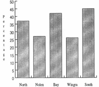
At least one quarter of the single family housing units in each of the neighborhood's five sub-areas was sold during the period 1983 to 1988 (See Chart 2). Of the sub-areas, Wingra and Nolen had the least amount of turnover. The highest rates of housing turnover in the last five years were in the South area, almost 45%, and in the Bay area, 37% of housing turnovers.
According to the 1990 Census, the percentage of owner-occupied units in Bay Creek was 46.3%, close to the city average of
45.8%. Renter occupied houses had a 51.3% turnover, with just 1.3% vacant. Most of the single family homes that were sold between
1983 - 1988 remained in single family ownership. By sub-area, both Wingra and the Bay present the highest percentage of owner
occupancy, with Nolen having the highest percentage of renters.
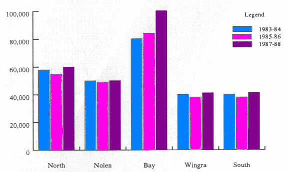
Average sale prices by sub-area have fluctuated. Except for the Bay area, where housing prices rose every year, each of
the other sub-areas experienced a slight decline in housing prices during 1985 - 86 as compared to 1983 - 84. But during 1987 -
88, sales prices increased moderately again (see Chart 3). During the 1987 - 88 period, the Bay sub-area had by far the highest
average sale price ($104,388), followed by Wingra ($65,007), North ($58,623), Nolen ($51,950), and South ($42,183). When average
sales prices are calculated on a per square foot basis (see Map 4), however, differences among the five sub-areas are much less
dramatic. Although the Bay area is still the highest at $59 per square foot, South, the lowest of the five areas, was not far
behind at $45 per square foot. This data shows that sales prices per square foot in the North area are virtually identical to
prices in the South area, $47 as compared to $45, although many residents and real estate agents perceive bigger differences in
sale prices between these two areas.
From 1983 to 1989, assessed values in the neighborhood increased considerably. The increase for assessment districts 21 (Vilas-Longfellow School) and 32 (South Madison), in which Bay Creek is included, are 21.3 and 20.3%, respectively. For the City of Madison, the average increase in assessment values during the same period was 16%. The area's higher percentage increase resulted from the city reassessing values in the neighborhood during this period. In 1989, the average single-family house in Bay Creek was still assessed at a low value compared to houses city-wide $58,518 to $73,892 but Bay Creek is still not the lowest assessed value district of the downtown districts. Average assessed values in Tenney Park, Lapham-Breese Stevens and Wil-Mar are lower than in Bay Creek, while Dudgeon-Monroe and Burr Oaks-Lincoln School assessed values are higher.
Located on approximately two acres of land along West Lakeside Street, Franklin Elementary School is one of the Madison School District's paired schools providing primary educational services for students in kindergarten, first and second grades. Approximately 124 of its 361 students live in the neighborhood. Children from the Randall, Bay View, and Bram's Addition neighborhoods walk, ride or take the bus to attend Franklin School. In addition to providing educational services, Franklin School provides a neighborhood playground facility with a paved ballfield, basketball hoops, children's playground equipment and a gymnasium.
Children from the neighborhood attend Randall School for third through fifth grade, Van Hise Middle School for sixth through eighth grades and West High School for ninth through twelfth grades.
Woodland Montessori School Inc. is a private school located in the eastern part of Bay Creek on Colby Street which provides pre-school educational services to 75 students.
A majority of Bay Creek residents responding to the telephone survey thought that neighborhood crime was likely to increase in the future. Madison Police department information on calls for service in Bay Creek shows, however, that crime was not on the rise from 1982 to 1988. The number of calls from the area about violent crimes (a crime that poses a threat of bodily harm) was stable during that period at about twenty a year. The number of calls about theft decreased by 27% during that seven-year period.
Bay Creek has access to an unusually large amount of park land and open space. Located immediately adjacent to Bay Creek is Olin-Turville Community Park. This park, a 108-acre facility, serves not only Bay Creek's residents but residents from a much larger area as well. Recreational facilities in Olin-Turville Community Park include a beach, boat launch, jogging path, cross-country ski trail, day camp sites, soccer and softball playing fields, shore fishing, a hiking path, nature trail and a restored prairie trail and various other improvements.
Franklin Field, located in the southeast corner of the neighborhood, is a 2.0 acre playing field that includes baseball diamonds, basketball courts, tennis courts, skating and hockey rinks, playing fields and shore fishing along Wingra Creek. Bernie s Beach is a 1.1 acre park located along South Shore Drive on Monona Bay with a swimming beach, shore fishing and a picnic area.
Several other small open space areas in Bay Creek include the Causeway Overlook, the Lawrence Street End, the Van Deusen Open Space and strips of land along Wingra Creek and Monona Bay. The Causeway Overlook, a 2.1 acre open space area located in the Nolen sub-area, includes a bike and jogging path and shore fishing in Lake Monona. The Lawrence Street End is a half-acre open space area along Lake Monona in the eastern part of the neighborhood that includes a boat storage area, shore fishing and a picnic area. The Van Deusen Open Space is almost two acres and is also located in the eastern part of the neighborhood.
Two additional open space areas stretch along much of the length of the shoreline of Wingra Creek and Monona Bay. The Wingra Creek shoreline is a linear open space area a mile long that connects Olin-Turville Park on the neighborhood's eastern boundary with Vilas Park and the Arboretum adjacent to the neighborhood's western boundary. The Monona Bay shoreline extends along the north edge of Bay Creek. It is used for shore fishing and offers a spectacular view of the State Capitol.
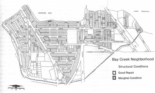
UPC surveyed exterior structural conditions of all Bay Creek buildings and found that 90% are in good condition (see Map
5). A four point scale ranging from good repair to bad condition was used (see Appendix 2). Most of the structures determined to
be in less than good repair are located in the South sub-area and the eastern part of the North sub-area. Generally, the
major deficiency in these structures is cracked and peeling paint. Only one structure in Bay Creek was found to be in poor
condition. It is located on Midland Street in the Wingra sub-area. The survey also revealed that a substantial amount of
external home improvement is taking place in the neighborhood.
Bay Creek has excellent links to other parts of Madison via a transportation network that includes some of the city's most
heavily traveled streets. Three heavily travelled arterials, John Nolen Drive, South Park Street and Fish Hatchery Road, bisect
Bay Creek making it one of the most accessible neighborhoods in the city (see Map 6) . With the recent completion of the South
Beltline project, John Nolen Drive has become a primary point of entry into the city. Persons traveling north into the Isthmus
area on John Nolen Drive are welcomed with an impressive view of the State Capitol and the downtown skyline. According to the
City of Madison's Department of Transportation, the average daily traffic volume on John Nolen Drive in 1988 was 30,750 vehicles.
Traffic flow projections prepared by the Dane County Regional Planning Commission predict that 34,000 vehicles will travel on
John Nolen Drive by the year 2010. However, traffic flow projections are only an estimate based on current conditions and past
trends. Factors such as changes in population and land use can have a dramatic effect on actual future traffic volumes as would
development and mass transit.
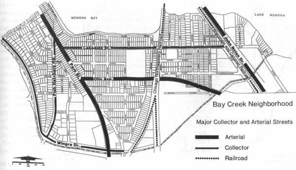
South Park Street is the second arterial street serving Bay Creek. During 1988, its average daily traffic flow was 37,850 vehicles according to the City's Department of Transportation. The Dane County Regional Planning Commission projects that its average daily traffic flow will be 44,286 vehicles by the year 2010. South Park Street does not share the characteristics typical of many arterials (i.e. restrictions on driveway access and on-street parking). It, like other strip commercial development, is characterized by an excessive number of driveways serving businesses located on the arterial street. Driveways along an arterial can cause a number of problems including reducing the carrying capacity of the street, increasing traffic congestion, and disrupting traffic flow.
Reconstruction of South Park Street, from the Octopus Car Wash to Cedar Street, occurred in 1991 and 1992. This project replaced curbs and gutters, grade and repave the roadway, and buried some utility wires. Currently, the City is working to improve the Street's visual quality by planting trees and shrubs as part of its boulevard beautification program. John Nolen Drive is also being considered for this program. A few streets in the South sub-area, including Spruce and Hickory, were also found to be in need of repair.
The third arterial serving the neighborhood is Fish Hatchery Road, an entrance point receiving traffic flow from the western part of the city. During 1990, its average daily traffic flow was 18,383 vehicles with traffic flow projection of 21,972 by the year 2010. Four residential streets intersect Fish Hatchery-Spruce, Midland, High and South Brooks Street--making it difficult to access them in high peak times.
Fish Hatchery Road is a two-lane road with unrestricted parking on its north and south sides from about South Park Street to Wingra Drive. Neighborhood residents would like to see the removal of parking on the segment of Fish Hatchery Road from North Wingra Drive to South Park Street to ease the traffic congestion.
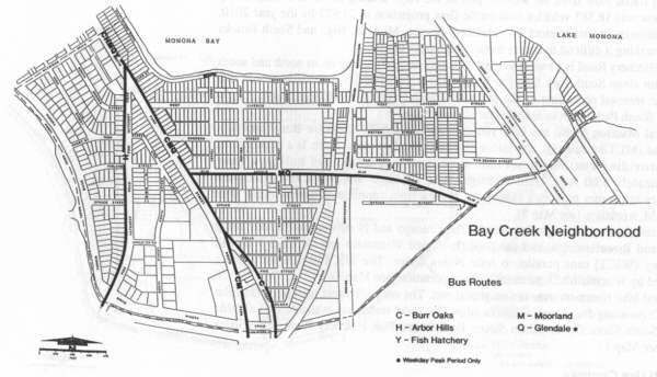
Several Madison Metro bus lines run through Bay Creek: Lakeview-Burr Oaks (C), Moorland (M), Glendale (Q), and Arbor Hill
(H). The Burr Oaks route is a primary bus route providing continuous service weekdays, weekends, and holidays from approximately
5:00 A.M. until midnight. The Glendale and Moorland routes are secondary bus routes providing continuous service from
approximately 6:00 A.M. until 10:00 P.M. weekdays (see Map 8).
Two rail lines run through Bay Creek. The Chicago and Northwestern extends along Gilson and Rowell streets, and the publicly-owned Wisconsin and Calumet Railroad Company (WICT) runs parallel to John Nolen Drive. The WICT is currently being improved by Wisconsin's Department of Transportation (see Map 6).
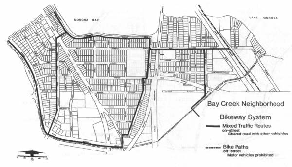
Several bike routes traverse the neighborhood. The only off-street path parallels John Nolen Drive along Bay Creek's
eastern edge. On street routes are available on Lakeside Street, South Shore Drive, Gilson Street, Beld Street, Fish Hatchery
Road and Wingra Drive (see Map 7).
Land use development in Bay Creek is regulated by the City of Madison Zoning Ordinance. Ten different zoning districts are
found in Bay Creek. The predominant one is the R 2 single family residence district which permits single family homes on 6,000
square foot lots. The largest clusters of land zoned R 2 are found along Wingra Drive, north of West Olin Avenue between Hickory
Street and South Park Street; north of West Lakeside Street between the Chicago and Northwestern Rail line and John Nolen Drive;
and south of West Lakeside Street between Rowell Street and Colby Street. The largest clusters of land zoned for multi family
residential units are located in the northwest portion of Bay Creek along High Street, South Brooks Street and Fish Hatchery
Road; and in the central part of the neighborhood along West Olin Avenue and Gilson Street. These areas are zoned R 4 and R 5
General residence which permit a variety of multi family uses. The location of neighborhood zoning districts is depicted on Map
9.
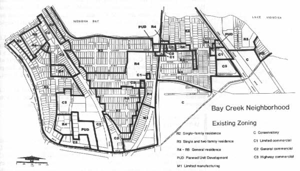
The primary commercial zoning districts in Bay Creek are the C-1 Limited Commercial District which permits retail convenience goods and personal services; the C-2 General Commercial district which permits a wider range of uses and a higher intensity of uses than the C-1 district and the C-3 Highway Commercial district which is for retail businesses requiring a location on heavily travelled thoroughfares. The primary commercially zoned areas in Bay Creek are found along South Park Street, West Lakeside Street, and John Nolen Drive.
A small portion of the neighborhood along Gilson Street is zoned M-1 Limited Manufacturing. Permitted uses in the M-1 district are non-nuisance industrial and commercial uses, specialized manufacturing uses and research institutions.
The John Nolen Drive Urban Design District is an important regulatory mechanism for guiding development in a portion of the
Bay Creek neighborhood. The Urban Design District is intended to provide an aesthetically pleasing entry way into the City of
Madison via John Nolen Drive (See Map 10). All major remodeling plans for existing buildings, as well as construction plans for
new buildings, must be approved by the City Plan Commission upon recommendation of the Urban Design Commission prior to the
issuance of any building, demolition or excavation permits for projects located within the Urban Design District. When reviewing
plans for development in the district, the Urban Design Commission considers site planning, landscaping, the siting of
structures, lighting, utility service, signs, screening of parking and service areas, and building design.
An additional mechanism for guiding development in the Bay Creek neighborhood is the City of Madison's Land Use Plan which
was prepared and adopted in 1983. The Land Use Plan provides policies for guiding future development in the City of Madison
between the present and the year 2000. Because Bay Creek is almost completely developed at this time, the recommended land uses
delineated on Map 11 generally mirror the existing development pattern in the neighborhood. One major exception is the commercial
area on West Lakeside Street. Although zoned for commercial uses (C-1), the area is designated as an area for low to medium
density residential development (RLM-S) on the Land Use Plan map. Another area where the zoning districts do not conform with the
Land Use Plan designations is the land along Sayle Street abutting the WICT rail line along John Nolen Drive. This land is zoned
for commercial uses (C-1 and C-3) while the Land Use Plan Map shows it for medium density multi unit housing (RM-M) in the
future.
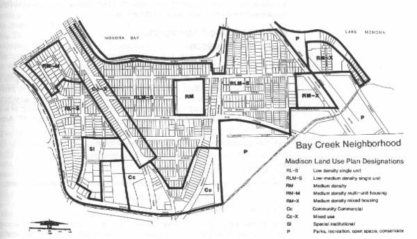
The primary land use recommended for Bay Creek is single family residential uses at 8-15 dwelling units per acre (RLM-S). Other residential uses depicted for the neighborhood are residential low density single family units at less than eight dwelling units per acre; multi family residential dwelling units at 16-25 units per acre (RM-M); single family, duplex and three and four unit residential units at 16-25 units per acre (RM-X) and medium density residential units at 16-25 units per acre (RM). All recommended residential land uses are generally consistent with the existing land use pattern in the neighborhood.
Special institutional uses (SI) are depicted for the area bounded by Appleton Road, Fish Hatchery Road, and South Park
Street in the Wingra sub area. This area currently includes an elderly housing facility and the Dean Medical Clinic. A mixture
of commercial and residential uses is recommended for the South Park Street Commercial area (CC-X (12)). Development in this area
is encouraged under planned unit development controls. The areas adjacent to Gilson Street, Beld Street and a portion of South
Park Street in the South sub-area are recommended for community commercial uses (CC) such as medical services, business
services, and retail establishments that serve a large portion of the city's residents with a wide range of goods and services.
The final set of land uses recommended for the Bay Creek Neighborhood includes parks, recreation, open space and conservancy uses
(P). These uses are recommended for the existing parks and open spaces in the neighborhood.
Neighborhood Strengths and Weaknesses
The scanning studies led to a clearer understanding of Bay Creek's strengths and weaknesses. Residents played a critical role in identifying positive and less positive qualities of the neighborhood. At two meetings in the late summer of 1989, members of the Neighborhood Steering Committee, participating in a nominal group process, responded to the question what should be done to improve the neighborhood? Among the top-ranked improvements were the following:
In effect, members of the Neighborhood Steering Committee were pointing to weaknesses in the neighborhood by stating what they would like to see improved. For example, giving priority to creating a positive neighborhood identity implicitly meant that residents believed that Bay Creek lacks such an identity.
At the same meetings, Neighborhood Steering Committee members also identified positive qualities about the neighborhood. The most significant of these were the affordability of its housing, the friendliness among its residents, and its central location.
Additional ideas about the neighborhood's strengths and weaknesses came from the UPC's telephone survey of a random sample of 75 Bay Creek residents. Residents were asked to rate their level of satisfaction with 18 qualities about the neighborhood. In many respects, the views of this larger sample of residents paralleled the views of the smaller-sized Neighborhood Steering Committee. The top-ranked qualities were: quality of schools in the area, convenience to work place, closeness to downtown, value of the home as an investment, friendliness among residents, and condition of recreational facilities and parks. They were most dissatisfied with the appearance of business areas, inconvenience to shopping, traffic conditions, and the appearance of the water bodies.
Merging the opinions of the Neighborhood Steering Committee members and residents who were interviewed in the telephone survey with what the UPC learned from their interviews, fieldwork, and secondary data source analysis, yields the following as the principal strengths and weaknesses of the Bay Creek neighborhood.
Two of Bay Creek's most important strengths are its excellent location and its strong array of environmental amenities. Bay Creek's location close to downtown and it being equally accessible to the west and east sides of Madison affords its residents easy access to jobs, health care (Dean Clinic, St. Marys Hospital, and Madison General Hospital) and recreational amenities (Olin-Turville Park, Monona Bay, Wingra Creek, and the UW Arboretum). With two of the city's principal roadways, Park Street and John Nolen Drive, cutting through the neighborhood, residents have excellent access to several nearby activity centers in the city. It is close to the larger retail businesses along the West Beltline, to the University, and to the downtown. With Olin Turville Park on its eastern edge and the UW Arboretum on its western edge, Bay Creek is well situated near two of Madison's largest recreational and open space areas.
Another important neighborhood strength is its unique boundary, largely unknown and unappreciated even by Bay Creek residents themselves. The discerning person who looks at a map of Bay Creek sees that the neighborhood is bounded almost completely by water. Monona Bay and Lake Monona, of course, are the most noticeable water boundaries on Bay Creek's northern edge. But with the exception of the four short blocks of Haywood Drive on the northwestern border of Bay Creek, the rest of the neighborhood's boundary follows the meandering path of Wingra Creek. The extensive water boundary could be used in marketing the area as a unique place to live.
Bay Creek also has bargain housing prices when compared to other areas of the city. Given the neighborhood's excellent location and environmental amenities, people who want to live closer to the downtown should find its housing prices quite attractive and competitive.
Bay Creek also has some weaknesses as a neighborhood. One of them, its lack of a clear identity, is clearly within the hands of concerned residents to rectify. Others, such as pollution of waterways, the unsightly appearance of business strips, and traffic problems, will require strong effort from concerned residents to garner government and affected property owner support to overcome.
The neighborhood now called Bay Creek had a distinctive presence in the past but currently has a less defined image. In the late 19th and early 20th century, for example, it was known as the area where the popular Monona Lake Assembly was located. Today, however, it is perhaps the least known of Madison's several downtown neighborhoods, although some of its residents say it may be one of Madison's better kept secrets.
One sign of the neighborhood's image problem is that people refer to it by several names. Unlike close by neighborhoods which are known by readily familiar names, for example, Brittingham Vilas to the northwest and Marquette to the east, the neighborhood that abuts Monona Bay on its north has been variously referred to over time as South Shore, Monona Bay, Franklin Lakeside, South Madison, Lakeside Olin, and even Murphy's Creek by a few of its old time residents. This lack of a clearly agreed upon name for the neighborhood recently prompted the Neighborhood Steering Committee to choose a new name for the neighborhood (the one used throughout this report), Bay Creek.
The profusion of neighborhood names is but one sign that the neighborhood lacks a clear image of itself. As the telephone survey of residents indicated, few respondents were much aware of neighborhood wide issues. This low level of interest in neighborhood affairs is partly due to the lack of an active neighborhood association to highlight neighborhood issues, capture the attention of its residents, and mobilize support for neighborhood projects. As the population in the neighborhood slowly changes, there are signs, however, that some residents are becoming more interested in what happens to the neighborhood as a whole. The recent tour of homes along South Shore Drive, West Lakeside Street, and a few nearby streets, in the fall of 1989, in connection with the Alternate Parade of Homes, is one indication. Even more important is the continued interest shown by members of the Neighborhood Steering Committee in this planning study. The nucleus of an active, prospective Bay Creek Neighborhood Association is evident.
Although one of Bay Creek's strengths is that it abuts Monona Bay and Wingra Creek, this proximity also presents a problem for the neighborhood. An abundance of weeds in these water bodies, especially in the summer, means that neighborhood residents cannot fully use these environment resources. The weed blooms, for example, reduce the recreational value of these waters by preventing some residents from swimming, boating, and fishing in them. During times when the stench from the weed filled waters is more noticeable, some even avoid walking, running, and biking along the shorelines. Wingra Creek's aesthetic quality is further impeded by occasional shopping carts and litter found along its shoreline.
The appearance of the business areas along South Park Street and in the smaller section of Gilson Street also present some problems. Many consider these areas to be generally unsightly which detracts from the neighborhood's image.
Another neighborhood concern is about the gradual disappearance of neighborhood retail stores in the heart of the neighborhood along Lakeside Street and, to a lesser extent, West Olin Avenue. While buildings in the Lakeside commercial district presently have no vacancies, the uses that replaced the former hardware and grocery stores on this strip lack orientation to the neighborhood.
Concerns have also been raised about the heavy volume of traffic that passes daily through Bay Creek from the stand points
of traffic and pedestrian safety and safe access to businesses along the three major arterials that run north and south through
the area, Fish Hatchery Road, South Park Street, and John Nolen Drive. These roads also have the effect of physically dividing
the neighborhood, possibly reducing interaction among residents living in its different sections.
Neighborhood Opportunities and Threats
Inevitably, Bay Creek will be affected by events and trends that occur outside of its boundaries. With little control over
these influences, the neighborhood can view them as opportunities it can capitalize on or threats it may try to diminish. The
most significant outside forces posing potential opportunities and threats to Bay Creek over the next five to ten years are
illustrated in Map 12. Although many of the forces are closely interrelated, each may be distinguished as falling primarily under
one of the following categories: the image and proximity to South Madison issue, market forces, and government actions.
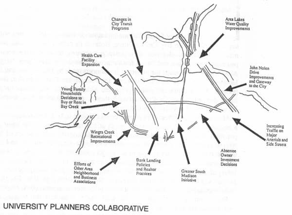
Bay Creek is situated directly north of the area known as South Madison. With more than the average share of difficulties, South Madison tends to project a more negative image than do most other neighborhoods in the city. Because of Bay Creek's proximity to South Madison, the latter's image tends to spill over the Wingra Creek boundary, affects some people's perception of Bay Creek. Bay Creek residents who were surveyed by telephone thought it likely that other city residents will continue to perceive Bay Creek somewhat negatively. The South Madison connection largely accounts for their opinion. Recent events and on going efforts, however, have started to turn that negative image into an opportunity.
In November 1989 the City announced a comprehensive approach to the problems facing South Madison. Known as the Greater South Madison Initiative, its effects, if successful, will reverberate throughout the southern and central portions of the City. This focused commitment, backed up by funds targeted to the area and emphasizing the importance of neighborhood involvement, promises to go a long way towards improving living conditions and increasing job training and placement activities in the area south of Bay Creek. As improvements are recognized over time and highlighted by media coverage, perceptions of South Madison will eventually become more positive. Bay Creek, because of its proximity to South Madison, stands to gain from this City effort.
While the City's initiative seeks to get at the root causes of the problems surrounding chronic underemployment, area citizens groups are working to enhance the image and community spirit of this part of the City. These efforts present an excellent opportunity for the Bay Creek Neighborhood Association to work together with the associations of adjacent neighborhoods, area business associations, and various coordinating bodies.
Whatever the Greater South Madison Initiative's outcome, market forces will have an important bearing on Bay Creek's future. Because its central location and good access make continued development a certainty, private investment decisions will present potential opportunities and threats for the neighborhood. The Bay Creek Neighborhood Association should gauge the impact of investments made by Dean Clinic and St. Mary's Hospital, development proposals along the John Nolen Drive corridor, the lending policies of area banks and realtor practices. Although these are not the only possible forces that will shape Bay Creek s future, they do represent the sort of information that the neighborhood association should regularly monitor.
More specifically, West Olin Avenue could continue to be a demarcation line between a housing market on the rise to the north and a declining one to the south, posing a potential threat to the neighborhood. Declining property values south of West Olin Avenue could cause a turnover from owner-to renter-occupied housing as buyers from outside Bay Creek would be able to get a high return on their investment, even from the lower rent levels that would accompany lower housing prices. The Bay Creek residents surveyed believe this is a threat their neighborhood is likely to experience. The lower property values could also decrease the incentive for Bay Creek owners, owner occupants as well as owners of rental properties, to maintain their properties.
But the survey reveals that residents think that it is unlikely that housing conditions will deteriorate and in an environment of an improving market perception, housing turnover may create an opportunity to eventually erase the West Olin Avenue dividing line. The aging of the neighborhood's population has resulted in a large number of houses coming on the market in Bay Creek. At the same time, John Nolen Drive is increasingly being recognized as the new entrance to the city, and the neighborhood is being rediscovered at least partly as a result of this new outlook. Younger families, who want to take advantage of the neighborhood's affordable housing and charm as well as its excellent location, are filtering into Bay Creek and renovating the homes. As long as this market trend, reinforced by realtor practices, continues on both sides of West Olin Avenue, the demarcation line will fade.
The market forces surrounding residential sales also create some unexpected possibilities. The young family market segment that is moving into Bay Creek offers an excellent opportunity for increasing the level of involvement with Franklin School. Better utilization of the facility for community recreational activities for neighborhood residents youth, adults and the elderly presents a way to create a neighborhood gathering place.
The houses becoming available pose another opportunity, this one for the elderly who are having to move. Some of the units they are having to vacate might be converted so that the elderly may be able to stay in Bay Creek (where many of them have been living for decades). Working in other Madison neighborhoods, Madison Mutual Housing Association, a local non profit housing corporation, has already completed several projects where it adapts existing structures to create elderly housing cooperatives for those who do not need high levels of care.
There is a downside to the market forces impacting Bay Creek. As the area is increasingly discovered, the potential for housing to become less affordable relative to other City neighborhoods is a threat widely recognized by the residents participating in the telephone survey. Lakeside commercial interests, particularly the neighborhood oriented retail establishments, are likely to have to continue their struggle against the economics that make national chains and shopping centers more competitive. While the possible increased traffic from the future development potential of John Nolen Drive could benefit the Lakeside commercial district, it could also turn neighborhood streets into throughways which could harm the quiet residential atmosphere as well as children's safety.
The last of the three external forces impacting Bay Creek is governmental action unrelated to South Madison. Several governmental agencies are in various stages of planning for improvements to one of Bay Creek's greatest assets, its water boundaries. Major regional planning efforts to improve Lake Monona, Monona Bay and Wingra Creek water quality are underway, and Bay Creek residents should maintain an awareness of the project's status. The City has plans for dredging Wingra Creek so that it could be navigated by canoe and for developing a bicycle/walking path along the Creek's shoreline. Increasing the Creek's use by not only Bay Creek residents but residents from all parts of the City will create an excellent opportunity to enhance Bay Creek's image.
As with the other external factors, government actions are not without their potential problems. The city wide bus system changes to a Dial a Ride system may further reduce the already sparse provision of public transportation to the area, and physical improvements to South Park Street may proceed without a comprehensive approach. The residents surveyed also perceived that the location of more group homes in Bay Creek was a threat more likely to occur. The surplus property surrounding the Dane County Coliseum may be developed in ways that will either benefit or threaten the neighborhood.
A characteristic common to all three of the categories is that each has elements of opportunity as well as threat. This
suggests that, to a certain extent, external forces can be controlled (or at least anticipated) so that missed chances or
problems can be minimized. That is why the commitment of the Bay Creek Neighborhood Association is so important.
Strategic Neighborhood Issues
With the neighborhood scanning studies completed, UPC moved to the stage of selecting strategic neighborhood issues to study. These issues would comprise the armature for developing more specific recommendations for neighborhood action.
More than 70 ideas for neighborhood improvement had been identified by Neighborhood Steering Committee members in the late summer 1989. Some were highly specific e.g. put more trash cans along Wingra Creek, move the bike path from John Nolen Drive to Olin Turville Park, enforce speed limits on West Olin Avenue and West Lakeside Street, clean up the business area on Gilson Street. Others were more general e.g. develop a more positive image for the neighborhood, provide more activity for youth, improve neighborhood communications, attract popular businesses. All of these ideas were ranked by the Neighborhood Steering Committee. The 8 top ranked ideas were: develop a positive image of the neighborhood; improve the physical appearance of the neighborhood; reuse the Ponderosa building as a job training center or roller rink; initiate a Neighborhood Watch program; clean up Monona Bay and Wingra Creek; create a neighborhood association; improve the business image on Park and Gilson Streets; and attract businesses to vacant commercial space.
These priorities, along with findings from the scanning studies, were what the UPC group used to frame a set of strategic issues for Neighborhood Steering Committee consideration at a mid October 1989 meeting. After discussion, agreement was reached on six strategic neighborhood issues for further study. Cast as strategic objectives, these were:
For each of the six strategic issues, UPC undertook a combination of field work, interviews, data collecting, and analyses of pertinent studies to derive possible recommendations for neighborhood action.
From these investigations, UPC developed a large number of alternative recommendations for each strategic objective. To
pare down the number, they applied two criteria-impact and feasibility. Those recommendations considered to have both a
potentially high impact on the strategic objective and a greater likelihood of being carried out in the next five years were the
ones UPC presented to the Neighborhood Steering Committee at a meeting in late November 1989. The Neighborhood Steering Committee
reviewed all 55 recommendations for neighborhood action listed in this report in January 1990 and selected their top priority
ones. These are indicated in the pages that follow. These pages list the recommendations for each of the six strategic
objectives. Each recommendation is presented in the following way: a brief description of the recommendation is given; the key
actors involved in implementation are listed; the year the recommendation should be undertaken is stated; and the possible
funding sources and estimated costs, if available, for the recommendation are given.
Improve the Image of the Neighborhood
A Bay Creek Neighborhood Association should be created with the intention of promoting the neighborhood, disseminating information, publishing a neighborhood newsletter and lobbying for neighborhood interests. Members of various neighborhood organizations such as school organizations, church groups, etc. should be brought together to form a single unified neighborhood association which focuses on issues that affect the neighborhood as a whole.
Key Actors: Neighborhood Steering Committee, residents, neighborhood businesses.
When: 1990
Funding Sources and Estimated Costs: No cost.
A neighborhood festival should be held annually to generate positive publicity for the neighborhood and enhance neighborhood identity. The festival could be a farmer's market, music festival, food festival, parade or all of these. One possible location for the festival is the vacant parcel of land near the Labor Temple at the corner of South Park Street and Wingra Drive.
Key Actors: Bay Creek Neighborhood Association, Bram's Addition Neighborhood Association, business associations.
When: 1990
Funding Sources and Estimated Costs: Business associations and private donations; $2,000 - $10,000
Linkage and coordination between the Bay Creek Neighborhood and adjacent neighborhoods should be encouraged. This could be accomplished through joint neighborhood projects such as Wingra Creek improvements, the Park Street Comprehensive Plan project, etc. Bay Creek needs to cooperate with adjacent neighborhoods because its future depends partly on what happens in these neighborhoods.
Key Actors: Bay Creek Neighborhood Association, Bram's Addition, Brittingham Vilas Neighborhood Association.
When: 1990
Funding Sources and Estimated Costs: No cost.
Improving the visual quality of the Bay Creek Neighborhood should be a priority. Special emphasis should be placed on tree planting and flower planting on neighborhood boulevards and terraces, neighborhood entrance signs, decorative banners, and burying utility wires. The neighborhood's major streets (South Park Street, John Nolen, West Olin, West Lakeside, Fish Hatchery) should be considered the highest priority areas since they are the primary entrance routes into the neighborhood. These improvements would help create a distinctive sense of place and neighborhood identity as well as enhance the aesthetic quality of the neighborhood. The theme of a neighborhood surrounded by water should be emphasized in these improvement projects.
Key Actors: Bay Creek Neighborhood Association, City Planning and Development staff, City Streets Department, City Parks Department, neighborhood business associations, MG&E
When: 1990 - 1993
Funding Sources and Estimated Cost: City budget, businesses, MG&E; $20,000+
Bay Creek residents should work together to create a neighborhood watch program. This resident based program would help to create neighborhood unity as well as to make residents more secure.
Key Actors: Bay Creek Neighborhood Association, Madison Police Department, neighborhood residents.
When: 1990
Funding Sources and Estimated Costs: Minimal cost since it is organized by neighborhood residents with assistance from the Madison Police Department.
The Bay Creek Neighborhood Association should work with the Madison Police Department to explore the feasibility of having an experimental police station or foot patrol in the neighborhood. This would help to create a safer neighborhood and would also encourage more persons to use neighborhood parks and businesses.
Key Actors: Bay Creek Neighborhood Association, Madison Police Department.
When: 1991
Funding Sources and Estimated Costs: City budget. Cost undetermined.
The owners of Bancroft Dairy should be contacted to examine the feasibility of painting a mural on the side of their building. A mural would help to improve the visual quality of the neighborhood and make the dairy's building more compatible with adjacent homes and businesses. A community wide competition for ideas could be sponsored by the Bay Creek Neighborhood Association along with associations of adjacent neighborhoods and business associations. This would be a high visibility project that could also help build a sense of community between Bay Creek and its neighbors.
Key Actors: Bancroft Dairy, Bay Creek Neighborhood Association, Dane County Cultural Affairs, UW Art Department, and South Madison Business Association.
When: 1991
Funding Sources and Estimated Costs: Private donations, area business associations, Dane County Cultural Affairs. Cost undetermined.
Have a neighborhood representative attend the Yahara-Monona watershed planning meetings with the dual purposes of providing neighborhood input and gathering information. One of the Watershed Project's local goals is to reduce weed growth in Lake Monona and Wingra Creek.
Key Actors: Dane County Regional Planning Commission, Yahara Monona Steering Committee, Bay Creek Neighborhood Association, Bram's Addition.
When: 1990
Funding Sources and Estimated Costs: 50 70% State of Wisconsin and 30 - 50% local (city and county); $1 - 2 million.
Work with Madison Park, Engineering and Transportation Departments and Bram's Addition Neighborhood Association in developing a plan to improve Wingra Creek and its shoreline. Such improvements could include dredging, community clean up of debris, shoreline improvements, canoe landing, and creating a continuous (off-road) hiking and biking path from Olin Turville Park to Vilas Park.
Key Actors: Transportation Department, Engineering Department, City Parks Department, Bay Creek Neighborhood Association, Bram's Addition Neighborhood Association, Youth Conservation Corp.,property owners.
When: 1990
Funding Sources and Estimated Costs: City Transportation Department, City budget, Federal Land and Water Conservation Grants; $15,000 - $150,000.
Although Franklin School is located in Bay Creek, there is little off hour use of the school by Bay Creek children or children from nearby neighborhoods. More neighborhood activities should be focused on the school to create more of a connection between the school and Bay Creek children and children from nearby neighborhoods.
Presently the Franklin school gym is used only on weeknights during the school year. Adding weekend and summer hours will expand its use for recreational purposes and possibly also as a neighborhood center.
Key Actors: Madison Metropolitan School District, Madison Community Recreation, Franklin School Principal, Bay Creek Neighborhood Association.
When: 1990
Funding Sources and Estimated Costs: User fees, Madison Community Recreation, Madison Metropolitan School District; $5,000 - $15,000.
The Bay Creek Neighborhood Association should contact Madison Metropolitan School District to improve the playground at Franklin School for neighborhood recreational use. Presently portions of the play ground have broken black top. If it was resurfaced and more play ground equipment added, neighborhood recreational use would improve.
Key Actors: Madison Metropolitan School District, Bay Creek Neighborhood Association.
When: 1990
Funding Sources and Estimated Costs: Madison Metropolitan School District, Madison Community Recreation; cost undetermined.
The Bay Creek Neighborhood Association should work with the City Parks Division to clean up storage facilities at Franklin Field and Sayle Street Storage Facility. Options such as screening and removal should be looked into to eliminate this eyesore.
Key Actors: City Parks Division, Bay Creek Neighborhood Association.
When: 1990
Funding Sources and Estimated Costs: City Transportation Department. Cost undetermined.
Although there are many regional parks in the area, Bay Creek lack centrally located small playlots for children to either walk to or ride their bikes to. The Neighborhood Association should contact the City Parks Department about using a couple of vacant lots for playlots.
Key Actors: City Parks Department, Bay Creek Neighborhood Association.
When: 1990
Funding Sources and Estimated Costs: City Parks Division, Bay Creek Neighborhood Association; $10,000 per playlot.
The Bay Creek Neighborhood Association should encourage the City Streets Department to improve the image and cleanliness of Wingra Creek and Monona Bay by adding more park benches and trash cans to these shorelines along Wingra Creek and Monona Bay.
Key Actors: City Parks Division, Bay Creek Neighborhood Association.
When: 1990
Funding Sources and Estimated Costs: City Streets Department, Bay Creek Neighborhood Association; $1,000 - $5,000.
Bay Creek Neighborhood Association should work with City Parks Department to increase lighting, improve maintenance, and add more playground equipment to Bernie's Beach at South Shore Drive and Gilson Streets and Midland Park.
Key Actors: City Parks Department, Bay Creek Neighborhood Association.
When: 1990
Funding Sources and Estimated Costs: City Parks Department; $2,000 - $24,000.
Develop Chicago and Northwestern rail line corridor for recreational purposes. There is a possibility that this rail line will be abandoned in the next five years. If so, the Bay Creek Neighborhood Association should approach the City Transportation, Parks and Planning and Development Departments to urge them to acquire and develop recreational opportunities along the railroad right of way. The trail, running north/south through Bay Creek could possibly be connected with the regional trail running east to west in Dane County.
Key Actors: City Transportation, Parks and Planning and Development Departments, State Department of Transportation, Bay Creek Neighborhood Association.
When: When track becomes abandoned.
Funding Sources and Estimated Costs: City budget, State Department of Transportation, Department of Natural Resources, Dane County Parks Department, $20,000 - $40,000
Eligible, low income senior citizens should be helped to maintain their houses in good condition for example, painting, weatherization, minor repairs, lawn care, house cleaning, etc. Such assistance will help them stay longer in the neighborhood.
Key Actors: South Madison Coalition for the Elderly, Project Home, Home Chore, Fresh Start, and other not-for-profit organizations.
When: 1990
Funding Sources and Estimated Costs: CDBG monies can be used for housing rehabilitation services. Cost undetermined.
The elderly should be given assistance to evaluate accessibility and safety features of their homes so that they can adapt to physical changes resulting from aging. Organizations like Independent Living provide these services. Special equipment and home modifications are often provided with charges based on income. Home safety programs help evaluate the elderly home environment and recommend adaptive equipment and structural modifications to facilitate independent daily living.
Key Actors: Independent Living, Visiting Nurse Association, Inc., and Project Home.
When: 1991
Funding Sources and Estimated Costs: CDBG, Independent Living, Inc., Project Home; cost undetermined
Create cooperative living arrangements for the elderly. There is a need for alternative housing for the elderly in the neighborhood since more of them are moving out of their single-family homes. Creating some cooperative living arrangements in the area would permit more older persons to remain in Bay Creek.
Key Actors: Madison Mutual Housing, Independent Living, Inc., PROJECT HOME.
When: 1991
Funding Sources and Estimated Costs: CDBG funds can be used to partially fund coop housing projects, Co-op Bank, area banks; cost undetermined.
The Bay Creek Neighborhood Association should provide information about housing alternatives. Information on rent assistance, public housing options, coop housing, nursing homes, etc. could be provided by the Neighborhood Association about the wide range of housing alternatives available in the community, especially to senior citizens.
Key Actors: Bay Creek Neighborhood Association, Madison Community Development Authority, South Madison Coalition for the Elderly.
When: 1990
Funding Sources and Estimated Costs: Minimal cost.
Promote home share arrangements for elderly home owners. Senior citizens who have a room to share in their homes should be matched with live-in persons who exchange household assistance and companionship for free or reduced rent.
Key Actors: Independent Living, Inc., Bay Creek Neighborhood Association
When: 1991
Funding Sources and Estimated Costs: Minimal cost.
Increase the frequency of Metro+Plus service or other similar paratransit systems. Metro+Plus is one of the transportation modes most utilized by older persons and handicapped individuals in the neighborhood. Metro+Plus, or other paratransit systems, should be made more available to the elderly in Bay Creek. The city wide demand for this service is doubling every three years.
Key Actors: Madison Metro, Bay Creek Neighborhood Association
When: 1990
Funding Sources and Estimated Costs: Madison Metro Plus; cost undetermined.
Expand Metro Ride services. Metro Ride offers specialized transportation to senior citizens and handicapped individuals who are medical assistance recipients. The existing service is not sufficient to satisfy the current demand beyond medical appointments. Metro Ride, or another service provider, should be expanded to include rides for shopping, educational and social activities of the elderly when it becomes economically feasible.
Key Actors: Metro Ride
When: 1991
Funding Sources and Estimated Costs: City, County; costs undetermined.
One alternative to meet the elderly needs for transportation would be to organize volunteers from Bay Creek to provide free or low cost rides to senior citizens.
Key Actors: Bay Creek Neighborhood Association, Bram's Addition Neighborhood Association, neighborhood churches, VFW, South Madison Coalition for the Elderly.
When: 1990
Funding Sources and Estimated Costs: no cost.
The number of outreach workers working in Bay Creek should be increased so that more senior citizens who need information on services for the elderly can be reached.
Key Actors: Dane County Mental Health Agency, South Madison Coalition for the Elderly.
When: 1990
Funding Sources and Estimated Costs: County, City, United Way; costs undetermined.
Establish an information network. The basic needs of senior citizens living in the area can be better met if service providers in the neighborhood coordinate their efforts to provide information about housing, transportation, and social activities.
Key Actors: Bay Creek Neighborhood Association, churches in the area, South Madison Coalition of the Elderly, Bram s Addition Neighborhood Association.
When: 1990
Funding Sources and Estimated Costs: no costs.
Intergenerational programs consisting of volunteer senior citizens tutoring school children should be promoted at Franklin School. Monthly lunches for school children served by elderly volunteers would be another way to use senior citizen resources.
Key Actors: Retired Senior Volunteer Program, Franklin School, Bay Creek Neighborhood Association.
When: 1990
Funding Sources and Estimated Costs: no costs.
Expand the existing nutrition sites at Romnes Apartments. Senior citizens who do not live at Romnes Apartments should be allowed to occasionally use its nutrition facilities.
Key Actors: South Madison Coalition of the Elderly
When: 1992
Funding Sources and Estimated Costs: Increased donations to the South Madison Coalition of the Elderly; cost undetermined.
Increase neighborhood awareness of future development potential and proposals along John Nolen Drive corridor. Continue the system of informing the neighborhood association of development proposals coming before the Urban Design Commission and the Planning Commission. Neighborhood association input into the review process is important to ensure that these Commissions require that developments oriented to the corridor to be design sensitive. It is also important for development proposals elsewhere either within or nearby Bay Creek.
Key Actors: Bay Creek Neighborhood Association, City of Madison Planning and Development Department, Urban Design Commission, City Planning Commission.
When: 1990
Funding Sources and Estimated Costs: no cost.
Businesses on Gilson Street should be encouraged to screen their parking and loading areas with vegetation or decorative fencing (i.e., wood or stone). Currently most businesses on this street are visually incompatible with the residential character of the surrounding properties. Screening of parking and loading areas would substantially enhance the aesthetic quality of this sub area.
Key Actors: Gilson Street business owners, Bay Creek Neighborhood Association, City Planning and Development Department, lending institutions.
When: 1991
Funding Sources and Estimated Costs: business owners; $10,000 - $20,000.
Redevelop vacant, dilapidated structure at the corner of Gilson and Wingra Streets. This building is the most significant blighting influence in an area of the neighborhood where market perception is hurting property values. Depending on conversations with the owner, the building could be reused or the site redeveloped.
Key Actors: Property owners, Community Development Block Grant Commission, Bay Creek Neighborhood Association, Community Development Authority (CDA) should a reuse be undertaken.
When: 1991
Funding Sources and Estimated Costs: CDBG, not for profit organizations, City Parks Department, CDA Capital Revolving Loan Fund for reuse; cost undetermined.
Extend the Madison Development Commission's (MDC) Business Call to the Gilson and West Lakeside Street area. Because MDC has already budgeted and scheduled this program to take place on South Park Street in 1990, efforts to redirect a project occurring in another part of the neighborhood stand a good chance of happening. This program offers technical assistance for general business financial planning. (For a more complete explanation of both MDC and its Business Call, please refer to the Glossary. The Bay Creek Neighborhood Association indicated it would rather see the program extended to the West Lakeside Street businesses first, but they would prefer if both areas could be approached. The Bay Creek Neighborhood Association should initiate discussions with MDC.
Key Actors: Bay Creek Neighborhood Association, City Planning and Development Department, MDC; costs undetermined.
When: Concurrent with other request.
Funding Sources and Estimated Costs: MDC; costs undetermined.
West Lakeside Street business owners should be encouraged to renovate their businesses. Special emphasis should be placed on creating a distinctive neighborhood retail district. This can be achieved by restoring original building facades, using decorative awnings and banners to create a sense of cohesion, improving the appearance of signs, and landscaping.
These improvements are eligible for Community Development Block Grant funds (however, final determination as to the funds use rests with the Community Development Block Grant Commission). The possibility of setting up a Revolving Loan Fund for the Lakeside and other Bay Creek businesses should be explored further. A comprehensive approach that combines physical improvements with efforts to foster a more complementary set of businesses and improved business planning could spark the area's rejuvenation.
Key Actors: Business owners, Bay Creek Neighborhood Association, City Planning and Development Department, CDBG.
When: 1990 - 1992
Funding Sources and Estimated Costs: CDBG, business owners; $50,000.
The Bay Creek Neighborhood Association should initiate discussions with the wholesale bakery about considering a retail counter. Neighborhood residents might first talk to Nature's Bakery on Williamson Street to anticipate any questions or concerns about costs, revenues and other issues that the West Lakeside Street bakery might have. This manageable effort would add a visible, neighborhood oriented, lively and low cost boost to the commercial area.
Key Actors: Bay Creek Neighborhood Association, wholesale bakery owner.
When: 1990
Funding Sources and Estimated Costs: MDC, if expansion loan is needed; cost undetermined.
The Bay Creek Neighborhood Association should decide upon a reasonable and desirable mix of tenants for the area through discussions with realtors, etc. and then approach Park Bank, MDC, CDA and commercial realtors. These proactive discussions could help focus on-going activities to Bay Creek's important neighborhood commercial center.
Key Actors: Bay Creek Neighborhood Association, Lakeside Business and Property Owners.
When: 1991
Funding Sources and Estimated Costs: no cost.
Increase neighborhood businesses awareness of programs and services offered by the Small Business Development Center (SBDC). The Bay Creek Neighborhood Association should obtain information from SBDC about its on-going (such as the Small Business Action Line which is a free service offering advice by telephone) and upcoming programs by getting on SBDC mailing list or by making periodic contact. Pertinent information should be published in the neighborhood newsletter.
Key Actors: Bay Creek Neighborhood Association.
When: 1990
Funding Sources and Estimated Costs: no cost.
If the Lakeside commercial district were to have significant occupancy problems in the future, the Bay Creek Neighborhood Association should consider the option of an adaptive reuse of the commercial structures for multi family housing combined with ground floor retail or office.
Key Actors: Property owners, Bay Creek Neighborhood Association.
When: 1992
Funding Sources and Estimated Costs: CDA's Capital Revolving Fund; cost undetermined.
A Comprehensive plan for the Park Street Corridor from the Beltline to the UW Campus should be developed by the City of Madison, the University, and the Town of Madison. The Plan should focus on business development, traffic engineering, land use, urban design, and beautification. The primary purpose of the plan is to guide development, improve traffic flow and improve the visual quality of Park Street, one of the entryways into the City and the UW Madison campus.
Key Actors: City Planning and Development Department, City Traffic Engineering, Bay Creek Neighborhood Association, UW Planning and Construction, Park Street business owners, South Madison Neighborhood, Town of Madison officials.
When: 1990 - 1995
Funding Sources and Estimated Costs: City, UW Madison, Town ; $50,000.
Reuse vacant structures along South Park Street for community oriented purposes. Several community uses (e.g., the Madison Area Technical College's South Madison Training Center and a teen recreation center or skating rink) are searching for a location in the area.
Key Actors: Various City agencies.
When: 1991 - 1993
Funding Sources and Estimated Costs: CDA's Capital Revolving Fund; costs undetermined.
Create a Business Improvement District (BID) for South Park Street. A BID is a special assessment district created at the initiative of businesses located in a specified area with the approval of the city (see Glossary for addition information on BIDs). A BID for South Park Street could supplement the City as a funding source to implement the Greater South Madison Initiative recommendations for business and economic development. These are to 1) develop area promotion and 2) designate a business developer to contact businesses (about a variety of subjects including assessment of expansion needs and any relocation intentions, etc.), to help package assistance and to promote the area.
Key Actors: South Madison Business Association, Fish Hatchery Road Business Association and MATC.
When: Coordinate timing with South Madison Business Association.
Funding Sources and Estimated Costs: The businesses in the area designated as a BID; costs undetermined.
Encourage South Madison businesses to increase minority hiring. Continue current City efforts to increase employment opportunities for area minority residents.
Key Actors: EOC, City Affirmative Action Office, South Madison Business Association, MATC, Bay Creek Neighborhood Association.
When: On going.
Funding Sources and Estimated Costs: no costs
Publicize existing public financing sources to encourage home ownership, home improvement and weatherization, and rehabilitation of rental properties. Low-interest loans to help homeowners maintain their homes or potential home buyers to own their home are available to persons who meet certain income requirements. Rental properties with a specified percentage of lower income households may also obtain low interest loans to fund rehabilitation. The Bay Creek Neighborhood is already a target area for these loans.
Key Actors: Wisconsin Housing and Economic Development Authority, City of Madison Community Development Authority, Madison Gas and Electric Company (for weatherization assistance).
When: 1990
Funding Sources and Estimated Costs: Actors above; costs undermined.
The Bay Creek Neighborhood Association should initiate inspection programs for specific properties. Have the neighborhood targeted for city building and environmental inspection by the city inspection unit. Although over 90% of the property in Bay Creek was found to be in good condition, some properties were under maintained. The common offenses were peeling paint, over grown weeds, and junk piles on the lots. These properties lower the overall quality of the neighborhood's housing and hurt its image.
Key Actors: City Building Inspection Unit, Bay Creek Neighborhood Association.
When: 1991
Funding Sources and Estimated Costs: City Inspection Unit; City Health Department, cost undetermined.
Encourage area banks to participate in the Wisconsin Housing and Neighborhood Conservation Program. Owner-occupants of residential structures with not more than four units that meet income limits are eligible to apply for these low-interest loans from participating banks. Loan funds may be used for permanent improvements to save energy, to correct health and safety problems such as wiring or plumbing or to improve livability. Loan amounts range from $1,000 - $15,000 but can only be made to cover the cost of the work.
Key Actors: Bay Creek Neighborhood Association, area banks.
When: 1990
Funding Sources and Estimated Costs: State funds, Bank loans; cost undetermined.
The Bay Creek Neighborhood Association should work with City Traffic Engineering to improve pedestrian safety crossings on South Park Street. Given increase traffic flows on South Park Street, safe pedestrian crossing for the young and the elderly will be more difficult. Other neighborhood associations along Park Street as well as the South Park Street Business Association should also be brought into the process since they too have an interest in this issue.
Key Actors: City Transportation Department, City Engineering, Bay Creek Neighborhood Association.
When: 1990
Funding Sources and Estimated Costs: City Transportation Department; costs undetermined.
Improve accessibility to public places by installing sidewalk on the northern boundary of Franklin Field and on the playground area. Install handicap ramps throughout the area.
Key Actors: City Engineering Department, City Parks Division, Bay Creek Neighborhood Association.
When: 1990
Funding Sources and Estimated Costs: City Capital Budget, CDBG funding; cost of up to $32,000.
Bay Creek Neighborhood Association, working with Saint Mary's Hospital and the City Transportation Department , should look at options to limit peak period traffic congestion on Wingra Drive west of Fish Hatchery Road. When shifts change at the hospital, traffic congestion sometimes becomes a problem at this intersection.
Key Actors: City Transportation Department, St. Mary's Hospital, Bay Creek Neighborhood Association.
When: 1991
Funding Sources and Estimated Costs: City Transportation Department; cost undetermined.
The Bay Creek Neighborhood Association should encourage the city Traffic Engineering unit to study the effect of removing parking on Fish Hatchery Road between Wingra Drive and S. Park Street. This will add 2 more lanes where there are currently only two lanes of traffic. This would eliminate the two lane bottle neck formed when lanes change from four to two lanes. Some residents of Bay Creek felt this was dangerous. Bike lanes should also be added.
Key Actors: City Transportation Department, Bay Creek Neighborhood Association.
When: 1990
Funding Sources and Estimated Costs: City Transportation Department; $1,000 - $2,000 and lost parking.
Enforce speed limits on West Lakeside Street and West Olin Avenue. Some neighborhood residents perceive that people drive too fast on West Lakeside Street and West Olin Avenue. Madison's Police Department should be encouraged to enforce speed limits on these two streets.
Key Actors: City Police Department, Bay Creek Neighborhood Association.
When: 1990
Funding Sources and Estimated Costs: Madison Police Department; cost undetermined.
Repave roads with broken blacktop in the neighborhood. Some roads in the South sub area are in poor condition and have broken black top. The Bay Creek Neighborhood Association should work with City Streets Department in prioritizing the roads that need the most maintenance.
Key Actors: City Streets Department, Bay Creek Neighborhood Association.
When: 1993
Funding Sources and Estimated Costs: City Engineering Department; costs undetermined.
Business Improvement District (BID) is a special assessment district created at the initiative of the businesses located in a specified geographic area with the approval of the City. The proceeds raised from the additional property tax assessment on the commercial properties in the district are used to fund the efforts to develop, manage, maintain or promote their area.
Community Development Authority (CDA) is a City of Madison entity that raises and allocates funds for housing and economic development in targeted revitalizing neighborhoods. Its two main programs are the Small Housing Rehabilitation Loan Program and the Capital Revolving Fund. Through the Housing Rehab Program, the CDA makes low interest, flexible repayment loans to home and apartment owners. The Capital Revolving Fund makes below market interest loans of up to $250,000 to desirable real estate projects (specified as those that create housing or commercial development or eliminate blight) within the target areas. Developers compete for funds from an annual loan pool that is expected to be about $500,000 in 1990. Priority is given to: 1) projects that meet more than one of the above criteria; 2) applicants who have not previously used the funds; and 3) projects serving a special need population.
Home+Plus is a consortium of Madison area individuals and agencies comprised of Independent Living, interested area REALTORS, and interested area builders/remodelers. Home+Plus provides assistance with builder or architect referral, necessary permits and financial consulting for the construction of accessory apartments. An accessory apartment is a self contained unit within a house.
Independent Living is a non profit agency designed to serve residents of Dane County who are over the age of sixty living in their own homes or apartments and who are able to remain there with some supportive services. Among the services offered by Independent Living are the Home Chore services which offer assistance to the elderly in their homes with house cleaning, lawn care, storm window and screen removal and installation, small paint jobs and minor repairs; Homeshare matches older persons with a room to share in their homes with live-in persons who exchange household assistance/companionship for free or reduced rent; and Occupational Therapy, which consists on a evaluation of the home for accessibility and safety to help the person adapt to physical changes that may result from aging. Special equipment and home modifications can be provided.
Madison Development Corporation (MDC) is a non profit local development corporation whose primary activity is small business lending. MDC is designed to make higher risk loans than private lenders to businesses located in Madison's targeted revitalizing neighborhoods. Under its Business Loan Program, MDC can lend up to $100,000 for working capital, inventory, equipment, leasehold improvements and business real estate. For large fixed asset projects, MDC can make loans of up to $500,000 through its Fixed Asset Loan Program. MDC regularly provides technical assistance for firms preparing loan application materials.
MDC's Business Call Program is an on going outreach program that is scheduled to target the businesses along South Park Street in 1990. MDC approaches the businesses with a survey mailing followed up with on-site visits. The purpose is two fold: 1) to assess the needs particular to the businesses there and 2) to inform the companies of available assistance. In conjunction with the Business Call, MDC offers technical assistance for general business financial planning.
Madison Senior Center is a multipurpose center designed to meet the needs and interests of older adults which is located on the Capitol Center housing development. It offers learning opportunities, hospitality, health programs and services, social services, information services, nutrition, recreational activities and events, and volunteer opportunities.
Metro Ride offers specialized transportation for disabled and elderly persons to destinations in the city, county, and state. Door through door transportation is provided to medical facilities, nursing homes, senior centers, social services, rehabilitation centers, and for personal business. Rides are available 24 hours a day, 7 days a week.
Project Home is a private, non profit organization that assists elderly, disabled and low income homeowners of Madison and Dane County with the repair, maintenance and weatherization of their homes.
Retired Senior Volunteer Program is a clearing house for county-wide volunteer opportunities for adults over the age of 67. It offers volunteer positions in over 150 non-profit and public agencies, group service projects, intergenerational programs, folk art fairs, oral history panels, nursing home activities and a driver escort program.
South Madison Coalition for the Elderly is a non profit social service agency providing outreach, needs assessment, nutrition, educational and recreation, and volunteer home chore services for the senior citizens. The South Madison Coalition's area extends form Randall Ave. to Martin Luther King Jr. Blvd., from Lake Mendota to the City Limits and the Town of Madison.
Visiting Nurse Service is a private, non profit agency that provides services to anyone in Madison and selected Dane County areas who needs a professional nurse, homemaker/home health aide, physical therapist, occupational therapist, speech therapist or social worker at home on a part time basis. All or part of service costs are paid by private health insurance, Medicare, Medicaid, U.A., or other societies.
The Wisconsin Housing and Neighborhood Conservation Program (HNCP) makes low interest home improvement loans available to low and moderate income homeowners. Participating banks have an agreement to sell the loans to the Wisconsin Housing Finance Authority (WHFA). WHFA, a quasi public agency with the power to sell tax exempt bonds at a low interest rate, uses the money from such bond sales to buy the HNCP loans from the lenders. There are currently more than 300 participating lenders throughout Wisconsin. Further information is available from the Wisconsin Department of Development.
| Numerical | Criteria Rank |
|---|---|
| 1 | In good repair with few, if any maintenance deficiencies. |
| 2 | In marginal condition, with one or more of the following deficiencies: exterior surface cracked; paint peeled; protective surface materials shifted from their normal position; material loose or missing, such as siding unattached or hanging; broken or cracked windowpanes; window frames loose or rotting; door and/or window screens missing or torn; outside porches and stairs rotting or broken; and, gutters missing. |
| 3 | In poor condition with major deficiencies, such as: roof obviously sagging; outside walls out of plumb; chimney missing or out of plumb; stairs and/or porches warped or settled; foundations leaning or sagging. |
| 4 | In bad condition with such structural deficiencies as to warrant condemnation and removal. |
[ Home | Publications | Calendar of Events | Projects | Contacts | Sites to Visit ] ~ [ site map ]
Webhosting donated by ![]()